Hunting Report
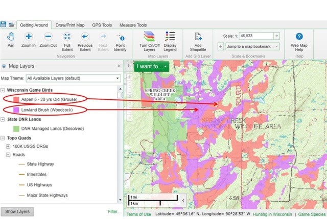
The Wisconsin Department of Natural Resources has developed a Fields & Forest Lands Interactive Gamebird Hunting Tool (FFLIGHT) designed to help upland gamebird hunters locate cover suitable for ruffed grouse and woodcock, managed dove fields and properties stocked with game farm pheasants. (Hint: the tools can be used to plot deer hunting locations, too). Hunters can access the tool using their desktop or mobile browsers to view public lands and turn on air photos for even greater detail.
Below is a screenshot from the FFLIGHT tool for reference:

The Wisconsin DNR has other web applications available that are useful for scouting out new areas to hunt. Try out one of the following:
- Location Finder Viewer – Welcome to the Location Finder Mapping Tool, a Wisconsin DNR interactive web mapping tool for searching and identifying locational information. This tool allows users to search for and retrieve information about a location such as the location’s county, municipality, PLSS description, Lat/Long, and legislative districts as well as names and ID numbers for waterbodies of the state.
- Private Forest Lands Open to Public Recreation – This web mapping application displays the approximate representations of over 1.3 million acres of Forest Tax Law Lands open to the public for hunting and fishing only, or hunting, fishing hiking, cross-country skiing, and sightseeing, depending on the program.
- Public Access Lands – Mapping application designed to provide access information on open public lands and recreational opportunities. Map themes, display DNR Land Sales parcels and Board of Commissioners of Public Land parcels are also include. The splash page provides web map usage and program details.
- FFLIGHT – This Fields and Forest Lands Interactive Gamebird Hunting Tool offers ruffed grouse, woodcock, pheasant and dove hunters an interactive summary of public hunting lands throughout Wisconsin.
- Guide for Wisconsin State Parks and Forests – Explore Wisconsin’s State Parks and Forests.
- Guide for Wisconsin’s Hunting and Wildlife – This offers useful hunting and wildlife watching information.
- Public Shooting Ranges in Wisconsin – Find a shooting range near you with this online map.
A complete list of interactive DNR maps can be found here: http://dnr.wi.gov/maps/gis/applist.html

Hunting Businesses


